Location
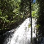
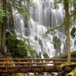
Ramona Falls drops 120 feet, cascading and splitting into ever smaller drapes broken up by the hexagonal columns of basalt at the base of the cliff. The special shape of the columnar basalt was formed in a lava eruption.
There is an 11,7km long loop trail to the falls. The south leg of the loop is less scenic but the north leg after the falls really enjoyable following the lush, green path of Ramona Creek and skirting towering cliffs before veering south to head back towards the trailhead.
There is an 11,7km long loop trail to the falls. The trail is moderate difficulty and takes about half a day to hike (4-6 hours). The trailhead is at the end of Muddy Fork Road and features a big gravel parking area.
NOTE: Not recommended to hike this trail during winter because a critical, temporary bridge early in the trail is removed each winter.
National Forest Recreation Pass - $5.00

